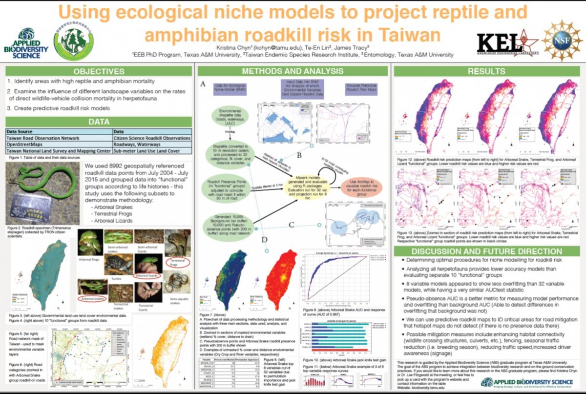
In the Anthropocene, the expansion of urban infrastructure, especially roads, brings ecological consequences to biodiversity. These consequences can be both indirect and direct; indirect road effects are those that are not directly associated with the road itself (e.g. habitat loss, edge effects, and genetic barriers) while direct impacts include faunal mortality during construction and during use of the road, most often due to wildlife-vehicle collision on roads. Ecological impacts of roads are expected to be especially dramatic in island ecosystems due to the high propensity for endemism and high rates of extinction, particularly among endemic species. Surprisingly, little research on the ecological effects of roads has been conducted on islands. Additionally, although roads heavily impact all terrestrial animals, amphibians and reptiles (herpetofauna) have the highest levels of road mortality. Our study takes a comparative approach in utilizing ecological niche models to examine the influence of different environmental and landscape variables on the rates of direct road mortality for herpetofauna at local and regional scales on the island of Taiwan. Since most roadkill studies are focused on local sections of road with high wildlife-vehicle mortality, this study elucidates regional landscape effects on road mortality in addition to local scale analyses and creates a predictive roadkill hotspot map for the entire island of Taiwan.
This project analyzes the influence of environmental variables (land cover, roads, and waterways) on 8,994 road kill presence points from over ten years (2004-2015) of data collected by the Taiwan Road Observation Network citizen science group. We created a predictive hotspot map to identify potential roadkill hotspots and the environmental variables that explain the presence of the most roadkill data across Taiwan. We employed the following models to identify areas and environmental variables with high roadkill impact (roadkill hotspots): Malo’s regression method (preferred method in literature), Ecological Niche Factor Analysis (ENFA), and a novel use of Maxent. We have preliminarily found that percent cover of cultivated land, distance to secondary roads, and waterway drains contributed the highest percent to faunal road mortality through novel Maxent analysis. (Additional model comparison analyses in progress.) We suggest focusing research on finer resolution ecological studies for these hotspots and environmental variables, and will conduct future ecological analyses that include bio-physical habitat variables for the identified herpetofaunal roadkill hotspots.
2016/8/7~12 Fort Lauderdale, Florida